The Dynamic Earth: How Natural Forces Shape Our Planet
Geologic Processes: Earthquakes and Volcanoes
MINDS ON
The Earth as you know it today, with its seven continents and five oceans, is not as static as you might think. During a human lifespan changes are almost imperceptible. However, over hundreds of millions of years, our planet has undergone tremendous change, evolving from an alien landscape to the familiar layout we are comfortable identifying with today. Whereas some landscape features are due to erosion and weathering, the process of plate tectonics is responsible, not only for its overall characteristics such as oceans and continents, but also for landscapes such as mountain ranges, volcanoes, valleys, ocean trenches, islands, and plateaus.
Understanding how the earth has changed geologically can help you interpret the processes that have shaped the landscape. The key idea is that land (definition:earth's crustal material above or below water) can move in two ways; horizontally (north, south, east, or west), or vertically (higher into the sky or lower into the Earth). All movement can be explained by understanding the action of geologic processes.
 Earth Video
Watch the video, Earth: 100 Million Years From Now. As you watch it, keep in mind the helpful information listed below and complete a two column chart organizer using the geographic language you learned in Unit 1 Activity 2. During the video, you will observe land moving in one or both of the ways mentioned above.
Keep in Mind
Land deep below water is dark blue and shallow water is light blue.
Land above water is green, brown or tan, but this colour indicates moisture only.
Land that appears grey and wrinkled indicates vertical uplift in mountain ranges.
Land that drops below sea level indicates depression (but also reflects changes in global sea level, unassociated with plate tectonics).
Self-Assessing and Goal Setting using Success Criteria
Which of these success criteria have you met in your See-Think-Wonder notes?
| Success Criteria | |
|---|---|
| I can describe the characteristics of patterns and trends using specific terms (e.g., patterns can be dispersed, concentrated, nucleated, linear) (trends can be long term, short term, seasonal, irregular, predictable). | |
| I can pose significant questions related to patterns and trends. | |
| I can clearly hypothesize natural/human characteristics responsible for patterns and trends. | |
| I can effectively use the concept of patterns and trends to assess hazard and disaster risk (e.g., the time interval of regular flood events and the area they typically affect). | |
| I can accurately describe different types of landscapes. |
Which of these success criteria do you still need to work on?
After watching the video, you may have more questions than answers. What is happening underground that can cause this much change to the Earth’s surface? Let’s find out!
ACTION
In Grade 9 Geography, you learned about some general aspects of the earth. Hover over to review this information as you are expected to have a working knowledge before we “dig deeper” into the processes driving plate tectonics. Keep track of your understanding by placing a checkmark beside each of the terms you fully understand. By the end of the review, you should research the meaning of any word without a checkmark before moving on to new content.
ReviewTerms
Taking our Previous Knowledge Further
The information you reviewed above provides the basis for tectonic theory (definition:This is a well-substantiated explanation of some aspect of the natural world, based on a body of facts that have been repeatedly confirmed through observation and experiment. Such fact-supported theories are not "guesses" but reliable accounts of the real world.) and the hazards geologic processes cause (earthquakes, volcanoes, landslides, and tsunamis). At the start of this activity, it was said that understanding processes beneath the Earth will allow us to explain what is happening on the Earth’s surface. Of all the geologic phenomena we could study, we will focus on five processes and the expected landscapes created by them. The catch is that you will be provided with essential information about a process, but not given example locations. You will have to predict where these processes are occurring by applying your understanding to the real world.
Process 1:
Convergent Boundary: Subduction Zones
When it comes to colliding tectonic plates there are obvious signs that you are standing on a subduction zone. Subduction zones occur where a less massive (but more dense) plate is being forced underneath another a much more massive (but less dense) plate. Continental plates (definition:Those with a continent on top, such as North American, South American, African, Eurasian, Indian, or Indo-Austrailian plates; these are large but float on the mantle due to their lower density.) act as a barrier to oceanic plates (definition:Those covered mostly by an ocean like the Nazca, Cocos, Pacific, and Philippine plates; these are thin but quite dense, making them more likely to sink into the mantle.), which have nowhere to go but to subduct underneath during the ongoing collision. Rather than a smooth interaction, subduction zones are well known for their crumple zones where land is deformed and pushed vertically into the sky on one side of a plate. On the opposite side of the subduction zone, the land (often beneath an ocean) is dragged downward as the plate it sits on is subducted beneath the continental plate. Thus, the process of subduction not only creates mountains on one side, but also a deep ocean trench on the other side.
Along with the vertical movement of solid crust, subduction zones are also known for volcanic activity. Heat and pressure created by the friction of the plates melts rock into magma. Interestingly enough, heat is only one aspect in the creation of magma. As oceanic crust is subducted, the water and carbon dioxide locked up in fossil organisms within the rock actually lower its melting point, allowing it to exist as a liquid.This magma can eventually find its way to the surface and erupts under immense pressure as a volcano. The following video summarizes subduction:
Here are a few characteristics you can use to identify a subduction zone.
- Presence of folded mountain ranges on one side of the plate boundary.
- A deep ocean trench on one side of the plate boundary.
- Presence of volcanoes along the plate boundary.
- Presence of frequent, often large earthquakes.
 Cool Fact
Process 2:
Convergent Boundary: Continental Collision
When two continental plates collide, an interesting process occurs that results in some magnificent landscapes. Unlike a subduction zone where one plate forces another underneath, during a continental collision, although massive, continental plates still have a much lower density than the mantle below so neither plate is willing or able to subduct (it is like trying to get an ice cube to sink in water). What happens when colliding plates cannot go down? They must go up! Locations experiencing a continental collision form the largest mountain ranges on earth. Mountains formed in this way dwarf the fold mountains that form at subduction zones.
Here are a few characteristics you can use to identify a continental collision.
- The colliding plates must both contain a continent at the location of impact
- Presence of large mountain ranges.
- Presence of frequent, often large, earthquakes.
Process 3:
Volcanic Hotspots
The most important aspect of volcanic hotspots is that they are the only tectonic landscape feature that does NOT occur along a plate boundary. Hotspots can occur anywhere else on Earth because their formation is controlled far below the Earth’s surface, even deeper than the motion of tectonic plates. Remember from the review information that heat is produced in the core. Sometimes, this heat can often find its way through the mantle with various results. Some locations receive more of this heat than others. Especially hot locations are termed “hot spots.” These are so incredibly hot that the magma within the mantle easily pierces the tectonic plate and erupts as a volcano at the surface. Tectonic plates, however, are continuously on the move; what results is the appearance of a line of both active and extinct volcanoes called volcanic arc islands.
It is important to remember that hot spots do not move. Rather, plates move over hot spots, giving the appearance that the hot spot has shifted. Hot spots are also associated with smaller but regular earthquake activity as the crust adjusts to shifting magma. Remember, it is much more valuable to know what is going on below the surface, because with this knowledge, we can accurately determine what is creating the landscapes we see. The following video summarizes the creation of hotspots:
Here are a few characteristics you can use to identify a volcanic hot spot.
- The volcano is located away from a plate boundary.
- Volcano(s) occur in a line or arc.
- There are less intense, but regularly occurring, earthquakes.
Process 4:
Divergent Boundary: Rift Valleys and Oceanic Ridges
Also known as constructive boundaries, locations where plates are pulling apart are the only places on earth where new crust is being formed. There are two situations in which these boundaries appear. First, in locations where continental plates are pulling apart, deep valleys are formed as the land collapses into the depression formed by separation. These rift valleys are the youngest areas of divergence. As a rift valley gets larger, it inevitably comes in contact with water (oceans, seas, or ground water). Initially, it appears as a narrow sea, but over millions of years of continuous spreading, rift valleys can create oceans as large as the Atlantic. Second, somewhere in between a rift valley and a vast ocean, the process alters slightly and the action that originally created a valley or depression now creates an elevated ridge as new magma pushes upward filling in the cracks. Both earthquake and traditional volcanic activity occurs less frequently at diverging boundaries. So, ironically, diverging plates can produce either mid-oceanic ridges or rises, or very early on, they produce rift valleys. The following video is an excellent summary of divergence:
Here are a few characteristics you can use to identify a divergent boundary.
- Plates are moving away from each other.
- There is a presence of a depression. Newly diverging plates form rift valleys
or
- There is the presence of an underwater ridge. Older diverging plates have created a sea or ocean with a ridge at the location of divergence.
- There is lower earthquake and volcanic activity.
Process 5:
Transform Boundaries
Transform boundaries occur where mantle convection causes two plates to simply slide past one another. Since there is no collision or separation, the landforms created at these boundaries are unspectacular in comparison to those created by other processes. These landscapes are limited to linear scars or interesting features where streambeds, roads, or other features are separated from each other as they cross the boundary. The most famous transform boundary is the the San Andreas Fault in California. Transform boundaries are known for powerful earthquakes as the jagged edges of passing plates easily lock in place building up pressure until the land gives way in a mass movement. Energy released in these moments causes the earthquake. As a general rule, the longer the time has passed between earthquakes, the more powerful the next will be as the mantle convection driving plate movement never stops - even though the plates may.
Here are a few characteristics you can use to identify a transform boundary.
- Small linear scars or valleys.
- Transform boundaries characteristically have few obvious features and are tough to identify.
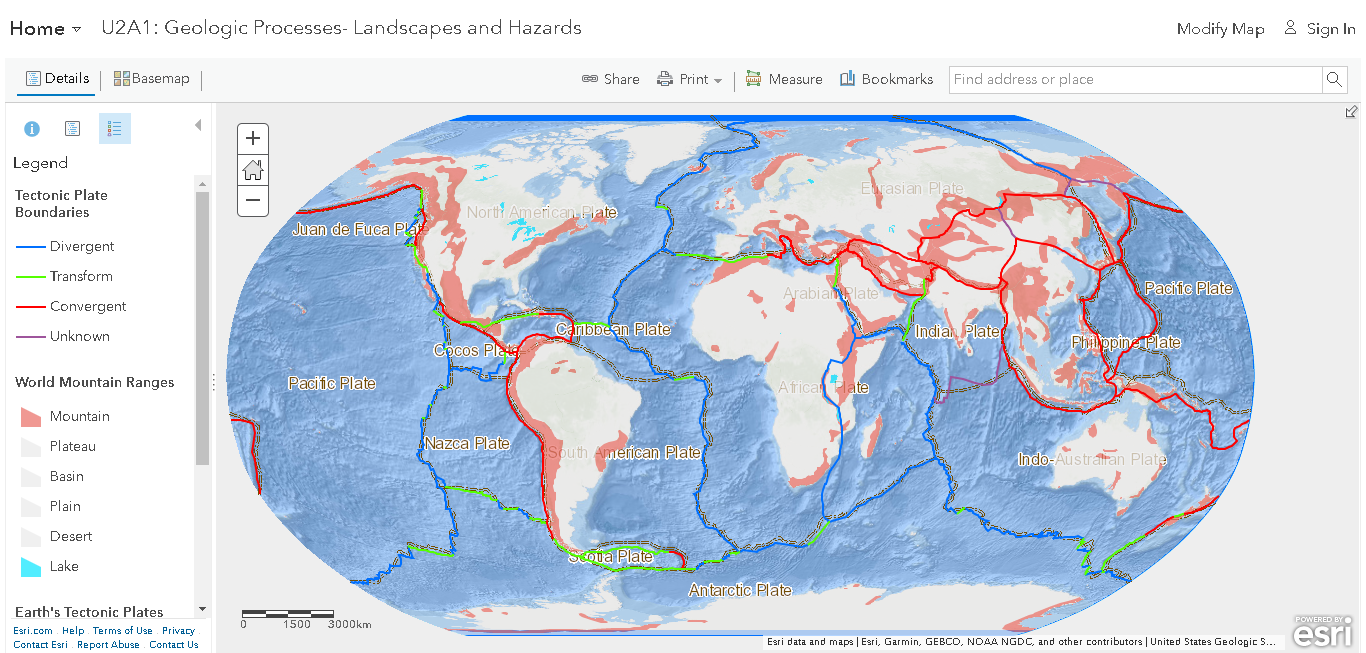
Now that you know more about the geologic and tectonic processes shaping the earth, it is time to study their patterns in greater detail. Take a look at the map below. It currently shows:
- the distribution of tectonic plates;
- the type of boundary created when plates interact; and
- information about the landscape created by interacting plates.
The following are not displayed:
- the location of recent earthquakes; and
- the location of volcanoes.
Use the legend to understand the features of the map. Click on “content” to turn on layers not displayed by placing a checkmark beside the layer.
Patterns from Tectonic Activity
Let's explore the patterns that form as a result of tectonic activity. Fill out this graphic organizer as a means of keeping track of all the information you gather. This task has you practicing the use of patterns and trends terminology as well as gathering and organizing information from a GIS map.
Consider the following as you complete the organizer:
| Success Criteria | |
|---|---|
| I can accurately describe different types of physical processes (e.g., geologic, atmospheric, hydrologic). | |
| I can describe the characteristics of patterns and trends using specific terms (e.g., patterns can be dispersed, concentrated, nucleated, linear) (trends can be long term, short term, seasonal, irregular, predictable). | |
| I can accurately describe how processes and hazards influence landscapes. | |
| I can analyse the connections between different types of processes/hazards and how they influence each other (e.g., geologic, atmospheric, hydrologic). | |
| I can accurately interpret geographic data and information using GIS to perform spatial analysis. |
CONSOLIDATION
Geologic processes such as plate tectonics impact the entire surface of the planet and have major influences on the location of natural hazards like earthquakes and volcanoes. So far, we have only studied large scale patterns in plate tectonics. Now we will focus on a particular location and perform a detailed analysis of the geologic processes influencing the landscape and hazard risk.
 Patterns and Trends Analysis
Complete a patterns and trends analysis for a geologically active location on earth.
PatternsandTrendsAnalysis
- Choose a location from the map that exists along a plate boundary, or has clear evidence of geologic activity/processes. This location should not be one already observed during the quiz.
- Take a screenshot of this location as a visual reference and include it in your analysis. Display any layers that you might want to refer to in your description (volcanoes, earthquakes, plate boundary types, etc.).
- Fill out a modified Patterns and Trends analysis using the typable learning object. The organizer you completed in the action section will be a great resource to draw information from to complete the analysis paragraph. Here is an example used in Unit 1 Activity 2. Note that this example is simplistic and does not take into consideration more detailed concepts and terms learned in this lesson.
PatternsTrendsTemplate